
A 2027 low tide calendar for your beach
Step 1 of 3
Choose your beach
Type a name to narrow the list, then pick your beach.
Pick a beach from the list to go on.
No beach matches that name.
California
- Enderts Beach, Redwood National and State Parks Del Norte County
- Trinidad State Beach Humboldt County
- Laguna Point, MacKerricher State Park Mendocino County
- Shell Beach, Sonoma Coast Sonoma County
- Gerstle Cove, Salt Point Sonoma County
- Agate Beach and Duxbury Reef, Bolinas Marin County
- Fitzgerald Marine Reserve, Moss Beach San Mateo County
- Bean Hollow State Beach San Mateo County
- Natural Bridges State Beach Santa Cruz County
- Pacific Grove Marine Gardens, Point Pinos Monterey County
- Asilomar State Beach Monterey County
- Weston Beach, Point Lobos Monterey County
- Corallina Cove, Montaña de Oro San Luis Obispo County
- Carpinteria State Beach Santa Barbara County
- Leo Carrillo State Beach Los Angeles County
- Abalone Cove Shoreline Park Los Angeles County
- Point Fermin, San Pedro Los Angeles County
- Little Corona del Mar Beach Orange County
- Crystal Cove State Park Orange County
- Treasure Island, Laguna Beach Orange County
- Doheny State Beach Orange County
- La Jolla Cove San Diego County
- Sunset Cliffs Natural Park San Diego County
- Cabrillo National Monument tide pools San Diego County
Oregon
- Haystack Rock, Cannon Beach Clatsop County
- Oceanside Beach Tillamook County
- Devils Punchbowl, Otter Rock Lincoln County
- Yaquina Head, Cobble Beach Lincoln County
- Seal Rock Lincoln County
- Cape Perpetua Marine Garden Lincoln County
- Sunset Bay State Park Coos County
- Harris Beach State Park Curry County
Washington
Step 2 of 3
What you get for your beach
One beach, the whole of 2027, every daylight low already picked and set out by month.
A PDF to print: a year page that marks every picked day, then a page for each month with the date, weekday, low time, height, window, sunrise and sunset.
A calendar file (.ics) that puts each picked day into Apple, Google or Outlook calendars, with the window as the event time and the limits in the note.
Both files in English and in Spanish.
Until 2027 starts, the rest of December 2026 comes with it.
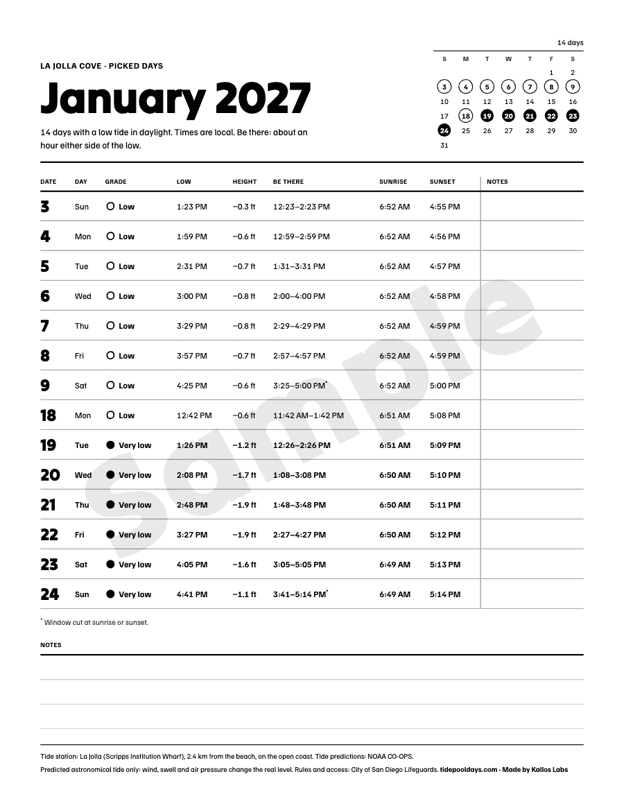

A sample month: La Jolla Cove, January 2027
| Date | Grade | Low | Height | Window | Sunrise | Sunset |
|---|---|---|---|---|---|---|
| Low | 1:23 PM | -0.3 ft | 12:23 PM to 2:23 PM | 6:52 AM | 4:55 PM | |
| Low | 1:59 PM | -0.6 ft | 12:59 PM to 2:59 PM | 6:52 AM | 4:56 PM | |
| Low | 2:31 PM | -0.7 ft | 1:31 PM to 3:31 PM | 6:52 AM | 4:57 PM | |
| Low | 3:00 PM | -0.8 ft | 2:00 PM to 4:00 PM | 6:52 AM | 4:58 PM | |
| Low | 3:29 PM | -0.8 ft | 2:29 PM to 4:29 PM | 6:52 AM | 4:59 PM | |
| Low | 3:57 PM | -0.7 ft | 2:57 PM to 4:57 PM | 6:52 AM | 4:59 PM | |
| Low | 4:25 PM | -0.6 ft | 3:25 PM to 5:00 PM | 6:52 AM | 5:00 PM |
Before you buy
These are predictions of the astronomical tide. Wind, swell and air pressure move the real water level.
The calendar says nothing about wildlife, access, collecting or how to look after yourself on the rocks; each beach page links the agency that manages it.
Razor clam digs open only on dates the state approves. The calendar shows tides, not open digs.
The tide numbers are NOAA's and free to everyone. What you pay for is the picking and the layout.
Step 3 of 3
Your calendar: your beach
- The 2027 calendar for one beach: the PDF and the calendar file, in English and in Spanish.
- One payment. Nothing renews and there is no subscription.
- Gumroad takes the payment and sends you the files to download.
$7, paid once
The calendar for this beach is not on sale yet.